
I Built What Calgary's Development Feedback Portal Should Look Like
Calgary is in the middle of one of the most significant housing policy debates in its history.
In 2024, Council passed a blanket rezoning bylaw allowing more housing types — duplexes, rowhouses, secondary suites — in neighbourhoods previously zoned exclusively for single-family homes. In March 2026, 323 residents spoke over five days of public hearings about whether to keep or repeal it.
But here's the problem: the City's existing tools for engaging with development data are fragmented, technical, and difficult for the average resident to navigate. Permit information is scattered across council agendas, PDF applications, and portals that require you to already know what you're looking for.
I thought there had to be a better way. So I built one.
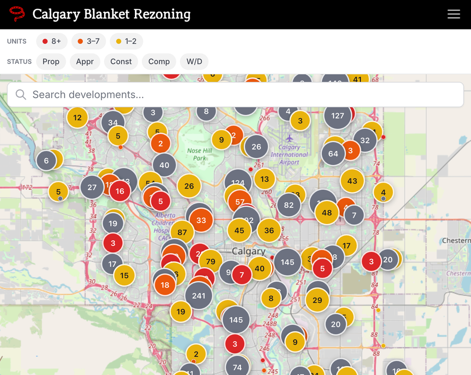
Calgary Blanket Rezoning (blanket-rezoning.vercel.app) is a free, web app that reimagines how residents should be able to engage with development permit data. It pulls directly from the City's Open Data portal and presents it the way it should be presented — visually, interactively, and accessibly.
What it does differently:
- Community photo documentation: Calgarians can upload photos of development sites alongside their feedback, building a visual story of how neighbourhoods are changing over time
- 5,000+ active development permits: Plotted on a single interactive map, colour-coded by density
- Filter by status: (Proposed, Approved, Under Construction), unit count, and neighbourhood
- Google Street View: Embedded on every address so you can see what's there today
- Direct links: To the City's Development Map for official permit records
- Geo-verified community feedback: Residents can submit input directly on any development
That last point is key. Feedback is restricted to Calgarians through browser-based location verification — not IP addresses that can be spoofed with a VPN, but actual GPS positioning. This ensures community input comes from the community.
Why I built it:
Since attending community meetings on blanket rezoning, I see firsthand how residents struggle to access and understand development information. People find out about new projects when construction starts — long after the public input window has closed. This tool was a personal project to explore whether civic data could be made genuinely accessible, not just technically available.
Most residents don't know how to navigate the City's permit system. They shouldn't have to. The information is public. It should feel public.
How it fits into the broader conversation:
PixelTree built an impressive data explorer that analyzes the March 2026 public hearing transcripts — 5,223 individual claims from 323 speakers, categorized by stance, evidence type, and ward.

Where PixelTree's tool focuses on what Calgarians said, this tool focuses on what's actually being built. Together, they paint a more complete picture of how Calgary's housing conversation is playing out — in the hearing room and on the ground.
What's next:
The app supports community photo documentation — residents can attach photos when submitting feedback, building a visual record of how neighbourhoods are changing over time. I'm continuing to refine the data, improve the filtering, and explore how tools like this could make civic engagement more meaningful across Calgary.
If you're in another city dealing with similar zoning changes, you're welcome to contact me and adapt it.
Try it: blanket-rezoning.vercel.app
Meeting of the Council Agenda: https://www.calgary.ca/council/meetings/agendas.html?redirect=/agenda
Member discussion